 |
Lake Wales (Current through Ordinance 2023-17, Adopted 7-05-2023) |
 |
Code of Ordinances |
|
Chapter 23. Zoning, Land Use And Development Regulation |
|
Article III. General Development Regulations |
|
Division 1. Land Development |
§ 23-303. Streets.
All streets shall be constructed in accordance with the standards of this section, unless specifically waived for a planned development project. All streets shall be public unless approved as private streets in a planned development project pursuant to section 23-224.
Sec. 23-303.1 Street layout. New streets shall extend existing street grids and patterns where feasible. Integrating new streets into the surrounding roadway network is favored over enclosed communities.
a. The street layout of a subdivision shall provide for the continuation or projection of streets already existing in areas adjacent to the areas being subdivided unless the approving body deems such continuation or extension undesirable for specific reasons of topography or design.
b. Where, in the opinion of the approving body, it is desirable to provide street access to adjoining properties, proposed streets shall be extended by dedication to the boundaries of such properties. Where the approving body deems it necessary, such dead-end streets shall be provided with a temporary turnaround having a radius of at least fifty (50) feet.
c. The street system for the proposed subdivision shall provide for extending existing streets at the same or greater width, but in no case shall a street extension be of less width than the minimum width required by these land development regulations for a street in its category.
Sec. 23-303.2 Street classification system.
a. Street classification system. The street classification system is established consistent with the Transportation Element and map of the Comprehensive Plan to ensure the expansion of a roadway network adequate to serve the needs of future development. The roadway functional classifications group streets and highways according to the character of service they are intended to provide in relation to the total road network. The Federal Highway Administration defines the basic categories as follows:
Functional System
Services Provided
Arterial
Provides the highest level of service at the greatest speed for the longest uninterrupted distance, with some degree of access control.
Collector
Provides a less highly developed level of service at a lower speed for shorter distances by collecting traffic from local roads and connecting them with arterials.
Local
Consists of all roads not defined as arterials or collectors; primarily provides access to land with little or no through movement.
b. Classification of Lake Wales Streets
Streets providing service within the city are classified as arterials, major or minor collectors, and local roads as follows:
1. Arterial highways. Arterials are part of a network of continuous routes serving substantial statewide travel by connecting urbanized areas." The existing arterials within the city include:
State Road 60
U.S. Highway 27
2. Major collector roads. A major collector means a street which conducts moderate volumes of traffic between arterials and minor collectors or local streets and also provides access to abutting properties. Major collectors shall connect to arterials or other major collectors at both ends.
Major collectors in and immediately outside of the city that are part of the county road system include:
Buck Moore Road between Burns Avenue and State Road 60 (CR 17-B)
Burns Avenue, eastward from S.R. 17 (CR 17-A)
Central Avenue between U.S. 27 and S.R. 60
Eleventh Street southward from S. R. 60 (CR 17-B)
Masterpiece Rd. from Buck Moore Rd. to city limit
Mountain Lake Cut-off Road
Chalet Suzanne Road eastward from U.S. 27 (CR 17-A)
State Road 17(Alt. 25)
Thompson Nursery Road westward from U.S. 27
3. Minor collector roads.
Any new minor collector shall connect to another minor collector, an arterials, or a major collector at each end. Minor collectors shall not be dead-ends and shall not terminate at a local street.
The city street system includes a gridwork of street classified as minor urban collectors, including:
Campbell Avenue between Marietta Street and Eleventh Street
Central Avenue between U.S. 27 and Lake Shore Blvd.
Dr. Martin Luther King Blvd. between Dr. J.A. Wiltshire Avenue and S.R. 60
Dr. J.A. Wiltshire Avenue between G Street and North Wales Dr.
E Street between Florida Avenue and Dr. J.A. Wiltshire Blvd.
Eleventh Street between Lakeshore Blvd. and S.R. 60
Euclid Avenue between Seventh Street and Eight Street
First Street between Dr. J.A. Wiltshire Blvd. and Winston Avenue
Grove Avenue between 9th Street and 11th Street South
Hunt Brothers Road between US Highway 27 and City limit
Lake Shore Blvd.
Marietta Street from Lake Shore Blvd. to Campbell Avenue
Mountain Lake Cut-off Road from U.S. 27 to S. R. 17
Ninth Street South south of Cohasset Avenue
North Wales Drive between Burns Avenue and Lake Shore Blvd.
Orange Avenue between Wetmore Street and S.R. 17
Palm Avenue
Park Avenue between Lake Shore Blvd. and Dr. Martin Luther King Blvd.
Polk Avenue between S.R. 60 and Lake Shore Blvd.
Sessoms Avenue between Dr. Martin Luther King Blvd. and North Wales Dr.
Stuart Avenue between Dr. Martin Luther King Blvd. and S.R. 17
Third Street between S.R. 17 and Winston Avenue
Tillman Avenue between S.R. 17 and Wetmore Street
Tower Blvd. between Burns Avenue and Lake Shore Blvd.
Wetmore Street between Sessoms Avenue and Briggs Avenue
4. Local street. Local streets provide connections between individual properties and collectors or arterials. A local street is a route that has the function of providing accessibility to individual parcels of property in residential areas. Local streets carry light volumes of traffic and should be designed to discourage through traffic and encourage low vehicular speeds. Local streets existing in the city are all of those street not listed in this subsection as arterials, major collectors or minor collectors.
Sec. 23-303.3 Street Access Requirements.
a. Adequate access. Approval of any new development or expansion of an existing development shall be contingent upon provision of adequate access as provided in this section. "Adequate access" shall be determined by the permitting authority based upon the standards for streets in this section and in accordance with the concurrency requirements of article VII, div. 1.
1. No subdivision or planned development project shall be approved by the City Commission unless there is adequate access to the property via existing public streets or a commitment has been made by the applicant or by the city, county, or state in the applicable capital facilities plan, to render the access adequate to serve the proposed development at the level of service standards required under article VII of this chapter, concurrent with development of the property.
2. Every building hereafter erected or moved shall be on a lot with a minimum width of 20 feet adjacent to or abutting on a paved public street, or with access to a paved public street by means of a private street approved by the City Commission, which has a minimum of 24 feet wide right-of-way or easement. All structures shall be located on lots so as to provide safe and convenient access for servicing, fire protection and related emergencies and required off-street parking.
3. No building permit or site plan approval pursuant to section 23-222 shall be issued for construction or placement of a building on a lot unless that lot has adequate access. Provided the concurrency requirements of article VII are met, access shall be deemed adequate if the lot has the required frontage on a public street constructed to city standards or a private street meeting the standards required by the city at the time of its approval for construction. If the street is unpaved, or does not meet other design requirements of this section necessary for adequate service to the proposed development, the administrative official, or the planning board, as applicable, shall require the applicant to upgrade the street to provide adequate access, unless the improvements are scheduled by the city, county, or state, and will render access adequate at the time the proposed structures are occupied.
b. Development access requirements. New development shall not be approved unless the development has or will have access to streets to serve that development, based on the following criteria:
1. Commercial, industrial, and professional development.
A. Developments on two (2) acres or less may be accessed from local streets. Where parcels proposed for development have multiple frontages, access from a side street is encouraged.
B. Developments on parcels larger than two (2) acres and commercial, industrial, or professional complexes and subdivisions shall provide a consolidated entrance from an arterial or major collector road and provide a minor collector road within the development to access individual lots, buildings, or groups of buildings. The planning board may require the collector road to meet the standards for a major collector and may require additional entrances for large developments.
C. No entrance road shall have driveways or parking lot entrances to individual parcels located within one hundred fifty (150) feet of its intersection with an exterior roadway.
2. Residential development. Streets within new residential developments shall be designed to provide local streets within neighborhoods and collector roads to connect neighborhoods to major collectors and arterial streets, within and outside of the development.
A. No new residential subdivision or planned development with more than ten (10) lots or multi-family development with more than twelve (12) units shall be approved with primary access from a local street.
B. No new residential lots or multi-family buildings shall have direct access to an arterial or major collector street. Collectors and local streets shall be provided within such developments for access to individual lots and buildings.
C. No lots in new residential developments and no new multi-family buildings shall be approved or permitted on a local street unless the distance via local streets from the site to a minor collector street or street of higher classification is one thousand two hundred (1,200) feet or less.
D. A collector street within a new residential development shall meet the standards for a major collector if it serves five hundred (500) units or more.
Sec. 23-303.4 Entrance roads, intersections and blocks.
a. Entrance road requirements.
1. Distance of cross streets from project entrance. In any residential or non-residential development, a minimum distance of one hundred fifty (150) feet is required between the intersection of any entrance road to the development with a roadway exterior to the project and the intersection of a cross street or parking lot access. In residential developments with over one hundred (100) dwelling units, the minimum distance shall be increased by fifty (50) feet for every one hundred (100) dwelling units, rounded off to the nearest one hundred (100) dwelling units, with a maximum of four hundred (400) feet.
2. New residential development or neighborhoods with no more than one hundred fifty (150) dwelling units proposed may be allowed to only have one (1) entrance, subject to the approval of the Development Review Committee.
3. Primary entrance roads are those that provide the main access to a residential development or any entrance from an arterial or major collector street. Secondary entrances are those that provide access to a residential development in addition to the primary entrance or entrances. The following standards shall apply to all residential developments with over fifty (50) dwelling units:
i. An entrance shall be provided to each collector road on which the development has frontage.
ii. At least one (1) primary entrance shall be provided to a residential development, except that those with fewer than ten (10) single-family dwelling units or twelve (12) multi-family dwelling units are not required to meet this requirement unless it is feasible to extend the entrance street to serve additional development in the future.
iii. Primary entrance roads shall be designed to meet the standards for a minor collector street, with no driveways to individual lots located on the entrance road. The required length of a primary entrance road shall be proportional to the number of dwelling units within the development:
TABLE – DWELLING UNITS AND REQUIRED LENGTH OF ACCESS ROAD
Number of dwellings
Length of Primary Entrance Road
(Meeting major collector design standards)
Up to 100
150 feet
100—199
200 feet
200—299
250 feet
300—399
300 feet
400—499
350 feet
iv. A secondary entrance shall be provided for any development with over fifty (50) dwellings. A secondary entrance shall meet the requirements for a minor collector.
b. Block length. Block lengths shall not exceed one thousand two hundred (1,200) feet or be less than four hundred (400) feet.
c. Angle of intersection. Streets shall intersect as nearly as possible at right angles and no intersection shall be at an angle of less than sixty (60) degrees.
d. Curb radii. Street curb intersections shall be rounded by radii of at least twenty (20) feet. When the smallest angle of street intersection is less than seventy-five (75) degrees, the director of public works may require curb radii of greater length. Wherever necessary to permit the construction of a curb having a desirable radius without reducing the sidewalk at a street corner to less than normal width, the property line at such street corner shall be rounded or otherwise set back sufficiently to permit such curb construction.
Sec. 23-303.5 Dead-end streets (culs-de-sac). No collector or arterial street shall be a dead-end street. Dead-end streets shall not exceed nine hundred (900) feet in length. All dead-end streets shall have a T or L shaped turnaround area at the terminus unless a turnaround is required for fire apparatus per the following criteria.
a. Where a cul-de-sac exceeds one hundred (150) feet in length, an approved turnaround for fire apparatus shall be provided at the closed end. Said turnaround shall have a minimum centerline radius of fifty (50) feet. Radius measurement shall not include curb, greenway or sidewalk. A landscaped center island is required. The maximum radius of a center island on a cul-de-sac with a minimum centerline radius shall be fourteen (14) feet.
b. Where a cul-de-sac exceeds three hundred (300) feet in length, an approved turnaround for fire apparatus shall be provided at the closed end. Said turnaround shall have a minimum centerline radius of sixty (60) feet. Radius measurement shall not include curb, greenway or sidewalk. A landscaped center island is required. The maximum radius of a center island on a cul-de-sac with a minimum sixty-foot radius shall be twenty-four (24) feet.
Sec. 23-303.6. Right-of-way and pavement width. The following shall be the required right-of-way and pavement widths for the street classification categories:
TABLE 23-303A
RIGHT-OF-WAY AND PAVEMENT WIDTHSTREET
CLASSIFICATIONRIGHT-OF-WAY WIDTH MINIMUM PAVED LANE WIDTH MINIMUM
SHOULDER
WIDTHMINIMUM
DESIGN
SPEEDArterial 120 feet - - - Major Collector 84 feet 12 feet 6 feet 45 mph Minor Collector 66 feet 12 feet 4 feet 35 mph Local Street 50 feet 12 feet 18 inches 20 mph Sec. 23-303.7 Pavement specifications. Street pavement shall be as required by the director of public works. Pavement shall be designed to carry the expected traffic loads and shall conform with current standard specifications for city streets. All street pavements shall be of a stable type. Loose aggregate will not be considered a completed pavement.
Sec. 23-303.8 Curbs and gutters. Curbs and gutters shall be provided on all streets. Vertical curbs shall be not less than six (6) inches in height and Miami curb shall not be less than three (3) inches in height. All curbs shall conform with the design standards established by the director of public works. Backfill shall be higher than the curb and shall slope toward the curb in order to ensure that surface water drains into the storm drainage system. Exempt from these requirements are streets within the C-1 and C1-A zoning districts.
Sec. 23-303.9 Sidewalks. Sidewalks constructed in accordance with this section shall be provided in all new developments and along all streets on which a development has frontage, unless a specific waiver is granted. City commission approval is necessary for any waivers of sidewalk construction requested with preliminary subdivision plats or planned development project plans. Compliance with this section is also required as a condition of approval of any site plan, including a site plan for a change of use, unless a specific waiver is granted by the planning board or administrative official as provided in this section. Planning board approval is required for waivers of sidewalk construction with major site plans or special exception use permits; the administrative official may grant waivers with approval of minor site plans and changes of use.
A waiver may be granted in cases where the where the applicable permit granting authority deems the sidewalk to be unnecessary because of adequate pedestrian accommodations in the development or neighborhood or deems the cost of the improvement to be unreasonable in light of the magnitude of the change triggering the site plan review. The requirement for construction of sidewalks along arterial and major collector roadways may also be waived where there are no existing sidewalks to extend, provided the developer contributes funds to the city equivalent to the cost of paving the applicable length of five-foot concrete sidewalk, such funds to be used by the city to construct or repair sidewalks elsewhere within the city. Payments in lieu of construction shall be based upon prices in contracts currently available for city construction of sidewalks to city standards.
a. Sidewalks shall be provided on at least one (1) side of all local streets and minor collectors and on both sides of arterials and major collectors. In the C-1, D-MU and C-2R districts, sidewalks shall be provided on both sides of the street, regardless of the street classification.
b. Sidewalks shall be concrete and shall be a minimum of four (4) inches thick. Sidewalks shall be a minimum of five (5) feet wide in residential areas and eight (8) feet wide in mixed use and non-residential districts.
c. Except in the C-1 and D-MU district, there shall be at minimum a three-foot wide strip of landscaped area (as defined in section 23-307) between the sidewalk and curb in which a tree as defined in section 23-307 shall be planted every fifty (50) feet, at minimum. In planned development projects where adequate provision for pedestrian circulation is provided, the requirements of this section may be modified by the approving body.
d. Sidewalks shall be constructed as part of the street construction in a subdivision or planned development project unless surety has been accepted by the city commission to cover the cost of sidewalks, in which case, the sidewalks shall be completed in segments as adjacent buildings are completed. Certificates of use may be denied on properties where the sidewalk serving the property has not been completed. As part of the approval of a permit for a construction or alteration of a structure or parking area, the administrative official may require the construction or reconstruction of sidewalks in order to fulfill the requirements of this section.
(Ord. No. 2007-33, § 1, 9-4-2007)
Sec. 23-303.10 Curves in streets.
a. A tangent at least one hundred (100) feet long shall be introduced between reverse curves on arterial and collector streets.
b. Where there is a deflection angle of more than ten (10) degrees in the alignment of a street, a curve with a radius adequate to ensure safe sight distance shall be made. The minimum radii of curves shall be as shown in Table 23-303B.
TABLE 23-303B
MINIMUM CURVE RADIUS
(where there is a deflection angle greater than 10 degrees in the alignment of a street)STREET
CLASSIFICATIONMINIMUM
CURVE
RADIUSArterial 500 feet Major or Minor Collector 500 feet Local Street 100 feet c. Street jogs with center line offsets of less than one hundred twenty-five (125) feet shall not be made.
d. Every change in grade shall be connected by a vertical curve constructed so as to afford a minimum sight distance of two hundred (200) feet, said sight distance being measured from a driver's eyes, which are assumed to be four and one-half (4½) feet above the pavement surface, to an object four (4) inches high on the pavement. Profiles of all streets showing natural and finished grades, drawn to scale, may be required by the director of public works.
Sec. 23-303.11 Grades. All streets shall be designed so as to provide for the discharge of surface water from the pavement and from the right-of-way by grading and drainage facilities. The minimum street grade required for adequate drainage shall be as approved by the director of public works.
a. The minimum grade of all streets shall be 0.3 percent unless specifically approved by the director of public works.
b. Streets shall be designed so as to make them flood-free in order that properties served by such streets will not be isolated by floods. In flood-prone areas, the director of public works may require profiles and elevations of streets in order to determine the adequacy of design. Fill may be permitted by the director of public works provided that it does not adversely affect flood conditions of the surrounding properties. Street construction shall comply with Art. IV, Div. 1.Development in Flood Prone Areas as applicable.
c. All streets shall be graded to their full widths so that pavements and sidewalks can be constructed on the same level plane. Deviation from this standard due to special topographical conditions will be allowed only with the specific approval of the director of public works.
1. Preparation of the subgrade. Before grading is started, the entire right-of-way area shall first be cleared of all tree stumps, roots, brush and other objectionable materials and of all trees not intended for preservation. The subgrade shall be properly shaped, rolled and uniformly compacted to conform with the accepted cross section and grades.
2. Cuts. In cuts, all tree stumps, boulders, organic material, and other objectionable materials shall be removed to a depth of at least two (2) feet below the grade surface. Rock, when encountered, shall be scarified to depth of at least twelve (12) inches below the graded surface.
3. Fills. In fills, all tree stumps, boulders, organic material, soft clay, spongy material and other objectionable materials shall be removed to a depth of at least two (2) feet below the natural ground surface. This objectionable material as well as similar material from cuts shall be removed from the right-of-way area and disposed of in such a manner that it will not become incorporated in fills or hinder proper operation of the drainage system.
Sec. 23-303.12 Street lighting. Street lights shall be provided along all vehicular and pedestrian ways in all subdivisions and planned development projects. Light poles shall not exceed 14 feet in height and shall be located to provide sufficient lighting along all pedestrian pathways and streets. The style and placement of street lights shall be approved by the city prior to installation. In new developments, the style and placement shall be shown on the site development plans and reviewed in accordance with section 23-217. Street lights shall be located so as not to encroach on sidewalks.
Sec. 23-303.13 Street names.
a. Proposed streets which are obviously in alignment with other already existing and named streets shall bear the names of such existing streets.
b. The name of a proposed street which is not in alignment with an existing street shall not duplicate the name of any existing street in Polk County irrespective of the use of the suffix street, avenue, boulevard, drive, place, court, lane, road or similar suffix.
Sec. 23-303.14 Dedication of streets and utilities in subdivisions. All streets and utilities shall be dedicated to the city at the time of final plat approval of the subdivision unless the streets have been approved as private streets in a planned development project pursuant to section 23-224.
a. Dedication of right-of-way for new streets. The right-of-way for new streets to be dedicated shall be as follows:
TABLE 23-303C
RIGHT-OF-WAY DEDICATION REQUIREMENTSSTREET CLASSIFICATION* RIGHT-OF-WAY WIDTH Arterial 120 feet Major Collector 84 feet Minor Collector 66 feet Local Street 50 feet *See § 23-303.2 for definitions of these street categories.
b. Dedication of right-of-way for existing streets. Subdivisions platted along existing streets shall dedicate additional right-of-way if necessary to meet the minimum requirements for new streets set forth in Table 303C above.
1. The entire minimum right-of-way width shall be dedicated where the subdivision is on both sides of an existing street. When the subdivision is located on only one (1) side of an existing street, one-half (½) of the required right-of-way width measured from the center line of the existing street shall be dedicated.
2. Dedication of one-half (½) of the right-of-way for proposed streets along boundaries of land proposed for subdivision shall be prohibited except for arterial streets.
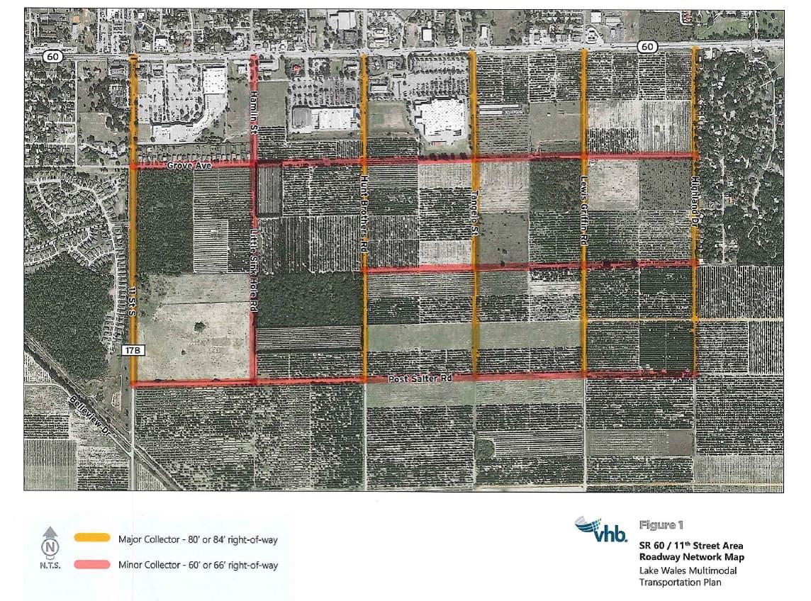
Sec. 23-303.15 State Road 60 / 11th Street Roadway Network Map
Appendix 1: Traffic Impact Study Guidelines and Requirements
Purpose & Intent
The purpose of the traffic impact study is to identify the potential impacts of new development on the City of Lake Wales transportation network and to provide information which will allow a concurrency determination to be made on each impacted segment. The traffic impact study will identify development traffic volumes on each impacted segment and intersection within a defined area, identify those roadway segments and intersections on which the adopted Level of Service cannot be maintained, include link and intersection analysis, and recommend potential solutions and/or mitigation for those segments and intersections on which the adopted Level of Service is not being met and the associated improvements necessary to regain concurrency.
The intent of this document is to define the requirements, procedures and methodology for the preparation and submission of a traffic impact study (TIS) in the City of Lake Wales and to provide an equitable, consistent and systematic means of determining the future impact of proposed developments while maintaining the adopted service levels on all roadways. Nothing contained in this document shall waive any requirement contained elsewhere in the Lake Wales Land Development Code.
Applicability
The requirements, procedures and methodology for a traffic impact study contained in this section shall apply to all development approvals in incorporated Lake Wales. In all cases, it will be the responsibility of the applicant to demonstrate to the Administrative Official and the Polk TPO that a proposed development will not unduly impact the road system.
Standard Requirements
As identified in Table 1: Traffic Study Requirements, there are three (3) levels of traffic studies that could be required. The study requirements and depth of analyses are defined for the three (3) study “tiers” in Table 1 and the subsequent sections.Table 1: Traffic Study Requirements Tier 1 – Traffic Review Tier 2 – "Minor Traffic Study" Tier 3 – "Major Traffic Study" Maximum AM or PM Peak Hour Two Way Net New Trips ≤ 50 51 to 99 > 99 See Section 1 for additional details. Methodology Methodology Letter/ Statement Not Required Required. See Section 2 for requirements. Methodology Meeting Not Required Not Required Required. A methodology letter shall be provided prior to the meeting for City review. Study Area Study Segments If the development accesses directly onto a segment identified on the Concurrency Determination Network, this segment shall be evaluated. If the directly accessed segment on the Concurrency Determination Network does not meet the adopted standard, backlogged, constrained orotherwise, the City may require study of additional segments and intersections. If the development does not directly access a segment on the Concurrency Determination Network, no segment evaluation will be required. Directly accessed segments on the Concurrency Determination Network and all roadway segments where peak hour project generated trips are estimated to consume 5% or more of the peak hour directional service volume, based on service volumes documented in the latest version of the Polk County TPO Roadway Network Database. Study Intersections Driveway Access Points Driveway access points and all signalized intersections and major unsignalized intersections for which an approach leg is a study segment. Technical/Evaluation Requirements Data Collection Intersection turning movement and roadway segment volume traffic data used in analysis shall be less than 12 months old (from the date that the methodology receives approval from the City) and shall be collected during periods of normal traffic conditions. Traffic volumes shall be adjusted to peak season using appropriate correction factors. Background Traffic Background traffic shall be based on historical growth rates, calculated from historic average annual daily traffic (AADT) data at nearby FDOT count stations, or other historic AADT data, if available. Include any vested trips documented within the buildout year, if directed by City or designee. In some cases, for a Tier 3 Study, additional planned development traffic may need to be incorporated if the combined level exceeds the historic growth factor in the study area roadway segments. Committed Improvements Projects identified for construction in the first three years of an adopted Work Program (WP), Transportation Improvement Program (TIP), or Capital Improvement Program (CIP), so long as the improvement is funded for construction consistent with the proposed buildout year. Trip Generation The latest edition of the ITE Trip Generation Manual shall be used for calculation of project trips. If authorized by the City or designee, trip generation data from other sources may be used in the analysis. The latest edition of the ITE Trip Generation Handbook shall be used to estimate pass-by trip reductions for non-residential developments. Internal capture estimates for mixed-use developments shall be based the methodology outlined in NCHRP 684. Trip Distribution/ Assignment Distribution and assignment may be based on existing traffic patterns. Distribution and assignment shall be based on traffic modeling using the currently approved and calibrated District One Regional Planning Model (D1RPM) unless an exemption is provided by the City or designee. Analysis Scenarios Segment and intersection analysis will be required for the following scenarios: Existing Scenario, Future No Build, and Future Build. If mitigation is needed to achieve adopted standards in the Future No Build or Future Build scenarios, additional scenarios, including the mitigation improvements, will be required. For multiphase developments, analysis of future No Build and Build scenarios will be required for each development phase. See Section 4 for additional details. Segment Analysis Peak hour, directional Level of Service (LOS) analysis shall be conducted for study segments under AM and PM peak hour conditions. See Section 5 for additional details. In certain cases, if the proposed project does not include residential uses, the requirement for AM peak hour analysis may be waived by the City. Intersection Analysis Peak hour LOS analyses shall be conducted for study intersections under AM and PM peak hour conditions. See Section 6 for additional details. In certain cases, if the proposed project does not include residential uses, the requirement for AM peak hour analysis may be waived by the City. Turn Lane/Access Analysis The need for turn lanes at proposed driveway access points shall be determined using the methods of NCHRP 745 for left-turn lanes and NCHRP 279 for right-turn lanes. This analysis should be conducted for the worst-case peak hour to determine the need for turn lanes. Traffic Study Requirements Content Trip Generation (Daily, AM and PM Peak Hour), Segment Analysis, and Driveway Peak Hour Analysis, and Turn Lane/Access Analysis. If the directly accessed segment on the Concurrency Determination Network does not meet the adopted standard, backlogged, constrained orotherwise, the City may require study and documentation of additional segments and intersections. Traffic study requirements are outlined in Section 8. Signed/Sealed by a Florida PE Not Required Yes Yes Review FDOT Review Not Required unless right-of-way permit is needed Yes, if the project trips are >5% on a state roadway and more than 3% on SIS or if right-of-way permit needed Traffic Study Tiers/Net External Trip Thresholds
The requirement for traffic studies are based on the net external AM or PM peak hour trips for the project, whichever is greatest, as determined by Table 1. For multi-phase developments, the trip thresholds are based on project buildout, not by phase. In cases of redevelopment, net external trips shall be based upon the new or proposed land use as compared to the land use existing at the time of redevelopment. Credit for prior use must be utilized in connection with a redevelopment of the site within one (1) year following the demolition of the existing structure or termination of the existing use, whichever first occurs.
Methodology Letter
A methodology letter is required for Tier 2 and Tier 3 traffic studies. An example methodology letter is included in the appendix to these guidelines. The applicant must submit the written methodology letter to the City and obtain written concurrence on the proposed methodology. Failure to do so may result in disapproval of the traffic impact study or a request for additional information and the requirement for a revised TIS. The methodology letter shall include the following information:- Project description.
- Anticipated buildout year for single phase developments and planned development phasing for multi-phase developments.
- Tier of traffic study being proposed.
- Site Location map.
- Site plan of the proposed development that shows the proposed access locations.
- Programmed improvements
- Map of the area of influence/study area.
- Table of proposed trip generation including pass-by trips and internal trip capture including land use description, ITE codes, trip rates or formulas and data used in the calculations from the latest edition of the ITE Trip Generation Manual and ITE Trip Generation Handbook. If authorized by the City or designee, trip generation data from other sources may be used in the analysis. If proposing an alternative source for trip generation data, attach study documentation, if already completed, or document the proposed methodology, consistent with guidance in the ITE Trip Generation Handbook, if an alternative trip generation rate is to be calculated based on observations of other sites.
- Proposed trip distribution in influence/study area.
- List of roadways that fall within the area of influence/study area.
- Identify any critical issues related to the project such as unacceptable roadway conditions, access constraints, public easements, etc.
- Proposed growth rate for calculation of background growth.
- Date of any traffic counts used in the analysis. Note: traffic counts more than one (1) year old cannot be used in the study unless approved by the City.
- Multimodal Assessment: evaluation of transit, bicycle and pedestrian accommodations as outlined in Section 3.
Multimodal Assessment
The multimodal assessment shall include an evaluation of existing and programmed bicycle, pedestrian, and transit mobility options. This assessment shall also discuss how the site plan encourages walking, bicycling and transit ridership through one or more of the following:- Safe, adequately lighting and well-maintained pathways
- Bicycle parking facilities
- Identifiable crosswalks
- Transit bus stops & transit stop amenities (i.e., bench, bus shelter, etc.)
- Removal of natural and/or built barriers that discourage walking
- Compliance with American’s with Disabilities Act (ADA) requirements
- Buffering between vehicular areas and sidewalks
- Linkage to existing or future walkway and/or bikeway network and transit route
Analysis Scenarios
Segment and intersection analysis will be required for the following scenarios. For multiphase developments include analysis of future No Build and Build scenarios for development phase.
Existing Scenario
AM (if required) and PM peak hour analysis of existing traffic on the existing transportation network.
Future No Build Scenario
AM (if required) and PM peak hour analysis of existing traffic, plus background traffic (derived from growth rates, vested trips, or combination of both), placed on the existing network, plus all improvements funded for construction within the first three years of the state, county or local jurisdiction’s adopted work program, capital improvement plan (CIP) and/or adopted transportation improvement plan (TIP).
Future Build Scenario
AM (if required) and PM peak hour analysis of existing traffic, plus background traffic (derived from growth rates, vested trips, or combination of both), plus the project's traffic placed on the existing network, plus all improvements funded for construction within the first three years of an adopted work program, CIP and/or TIP, and proposed project driveways/access improvements.
Future No Build Scenario with Mitigation (if necessary)
AM (if required) and PM peak hour analysis of the Future No Build Scenario with the inclusion of any other improvements that are required for mitigation. This analysis scenario will be required only if mitigation is required to obtain the adopted Level of Service as the result of the Future No Build Scenario analysis.
Future Build Scenario with Mitigation (if necessary)
AM (if required) and PM peak hour analysis of the Future Build Scenario with the inclusion of any other improvements that are required for mitigation. This analysis scenario will be required only if mitigation is required to obtain the adopted Level of Service as the result of the Future Build Scenario analysis.
Segment Analysis
AM (if required) and PM peak hour, directional Level of Service (LOS) analysis shall be conducted for study area segments based on currently accepted traffic engineering principles. Segment analysis should compare roadway volumes to the service volumes published in the latest edition of the Polk County TPO Roadway Network Database, if available, or the FDOT Generalized Service Volume Tables.
Methods that incorporate and apply appropriate techniques from the latest edition of the Highway Capacity Manual (HCM) are also acceptable. These methods may include the use of the latest available versions of the Highway Capacity Software (HCS), Synchro, or LOSPLAN, as approved by the City.
LOS Standards
The calculated LOS shall be compared to the adopted LOS standards used for concurrency determination and shall be consistent with the Transportation Element of the Lake Wales Comprehensive Plan.
Roadway Volumes
Existing roadway volumes may be established from the latest edition of the Polk County TPO Roadway Network Database (if available), counts from the Florida Department of Transportation (if available), or collected segment volumes (which may be derived from collected peak hour turning movement counts used for the subject TIS).
Roadway Service Volumes
Roadway service volumes will be provided in the Polk TPO Concurrency Network Database. In the event the information is not available, FDOT generalized level-of-service standards may be used upon confirmation by the City or designee. Roadway improvements programmed within the first three years of an adopted work program, TIP, or CIP may be utilized as long as the improvement is funded for construction consistent with the proposed buildout year for the development, but no more than three years from the date of the study.
Intersection Analysis
AM (if required) and PM peak hour LOS analyses shall be conducted for all study intersections based on currently accepted traffic engineering principles. Methods that incorporate and apply appropriate techniques from the latest edition of the Highway Capacity Manual (HCM) are acceptable. These methods may include the use of the latest available versions of the Highway Capacity Software (HCS) or Synchro. Microsimulation software may also be used but is not required.
LOS Standards
The existing LOS shall be compared to the adopted LOS standards used for concurrency determination and shall be consistent with the Transportation Element of the Lake Wales Comprehensive Plan. The LOS standards for an intersection analysis shall be the conservative adopted roadway LOS standard of the intersecting roadways.
Signalization
If signalization is proposed as a mitigation measure, a signal warrant analysis (including FDOT signal warrant summary worksheets) and a Stage 1 Intersection Control Evaluation (ICE) shall be provided for the location(s) proposed for signalization.
Turn Lane/Access Analysis
The need for turn lanes at proposed project access shall be determined using the methods of NCHRP 745 for left-turn lanes and NCHRP 279 for right-turn lanes. This analysis should be conducted for the worst-case peak hour to determine the need for turn lanes.
Crash/Safety Analysis (if City wants to include)
Traffic Study Requirements
Tier 2 and 3 traffic studies shall include the following elements.
Table of Contents, List of Figures, List of Tables- Introduction: project description, site location, site plan, study area/area of influence map, planned and programmed improvements and committed developments.
- Existing Roadway & Intersection Conditions: existing roadway segment geometry, existing intersection geometry, existing traffic volumes and existing segment and intersection LOS results. If a segment or intersection with a history of high crash occurrence exists within a study area, at the discretion of the City an evaluation of potential mitigating measures can be required.
- Future Roadway & Intersection Conditions: future roadway segment geometry and future intersection geometry.
- Future Traffic Conditions: background traffic, trip generation, trip distribution and assignment and future traffic volumes.
- Transportation Assessment: segment analysis, intersection analysis, and turn lane/access analysis for future conditions.
- Multimodal Assessment: evaluation of transit, bicycle, and pedestrian accommodations.
- Crash/Safety Analysis (if required)
- Mitigation Strategies: recommended improvements and proportionate share calculations.
- Summary/Conclusions: brief discussion to highlight the reason for the traffic study tier classification, methodology followed, general results of the analysis and action requested (e.g., approval of mitigation strategy).
- Appendix: approved methodology, traffic count data, site plan, capacity analysis summary sheets for existing conditions and future conditions, trip distribution plot from the travel demand model, and all other pertinent data to support the traffic study. For a Tier 2 or 3 study, the electronic operational analysis files (Synchro, HCS, etc.) shall be submitted with the report.
(Ord. No. 2006-24, §§ 4—7, 6-6-06; Ord. No. 2008-45, § 8, 12-16-08; Ord. No. 2015-04, § 6, 7-7-15; Ord. No. 2020-30, § 1, 12-02-20; Ord. No. 2022-03, § 1, 2-01-22; Ord. No. 2022-06, § 1, 3-01-22; Ord. No. 2022-30, § 1, 8-02-22; Ord. No. 2022-37, § 1, 9-07-22)